

A couple of years ago, we attempted to drive Quebec’s “Whale Road”, from the small town of Tadoussac to the end of the road, the teeny tiny town of Kegaska. But things didn’t go as planned. In the end, one of us got COVID, and we ferried over to the Gaspe Penninsula and had a different journey altogether. Van life is like that: ya gotta roll with it.

But we retained our fascination with northern Quebec, especially the famed route 138, the Whale Road. This road follows the western shore of the Saint Lawrence, from its river-y beginnings north of Quebec City, to where it passes through the Strait of Belle Isle, on the way to becoming the expansive Gulf of Saint Lawrence.
And this year, we decided to give it another go, driving the 1000 plus miles to the literal end of the road. Along the way, we hoped to see whales, experience remote beaches and rocky shores, try some local seafood and experience this unique part of North America.

The Whale Road was all that — and more! So if you are interested in a beautiful, remote and totally doable roadtrip, this article is for you.

A Few Important Details

A Land of Many Names
The road that traces the shore of the St Lawrence has a few different names: The Whale Road (or “Route des Baleines” in French), The Cote Nord (or “North Coast”) and Quebec Route 138. We’ll use these terms interchangeably in this article. The Whale Road is 1,420-kilometer, paved national highway that runs along the north shore of the St. Lawrence River
French is the Dominant Language
As the names indicate, this is a French speaking part of the country. As you travel up the coast, fewer and fewer people speak English. Signage is often in French only and though people are invariably friendly and kind, language can be a bit of a barrier here. A good language translation app will help– though the Northern Quebec accent is a far cry from classical French.
Visitor Information Centers are Key
There are many visitor information centers, “Halte Routières” in French, along Route 138 and they are key. The folks here will answer your questions (in French or English) and provide all sorts of information. In addition, many “halts” offer picnic tables, views, free overnight parking/camping, flush toilets, and other services. Here is a guide to the Halte routières along route 138.
Stock Up When You Can
While almost all the small towns along the route have a gas station and convenience store, there are only a few large enough for a full on supermarket. So stock up on groceries when you can (The larger towns of Baie Comeau and Sept Iles have the best selection by far).
Time Your Visit
If you want to see whales, your window of opportunity is July-September. Luckily, there are less mosquitoes, sand gnats, and black flies in late summer as well. We timed our visit badly our first time out, and didn’t see many whales. But the Cote was very quiet in mid May, which was lovely just the same. Once “whale season” starts in July, it is a busier on the Cote. Even so, we had no problem finding places to camp with no reservations in mid-summer.
Free camping is plentiful, but not always where you want it
There are many, many opportunities for free camping along the Cote Nord. You can park up at a variety of roadside stops as well as some free (or cheap) municipal campgrounds, town harbors/quais and wild strips of coast. This part of Quebec is popular with French speaking van travelers, and the iOverlander app does a great job of sharing available sites. But be warned: we found that many of the sheltered spots listed were too sheltered, meaning “buggy”. We suggest keeping a few sites in your “back pocket” in case the first doesn’t work out. (This is advice for anywhere you go really.)
Plan for Bugs and Weather
This is a wild coast, set beside a vast, boggy, trackless, northern wilderness. So expect that you might run into a few blackflies and mosquitoes. Expect a variety of weather too! And plan accordingly. We definitely appreciated our warm gear, raincoats, bug repellant and sun screen in July. “Summer” here can be cold…or hot. Sometimes in the same day. Wet and buggy too!
A Journey up the Coast
We’ll do our best to detail the places we explored on the way up the Cote Nord. But note: this is nowhere near a complete list of the awesomeness that awaits you on a trip up the North Coast of Quebec. Check out our post about our previous Cote Nord trip here.

Tadoussac
The small, tourist-friendy town of Tadoussac is the unofficial start of the Whale Road. To reach it, take the free ferry across the mouth of the Saguenay River (no need to reserve, just show up and wait in line). Tadoussac has a long and interesting history. It was a summer hunting and trading area for indigenous peoples for over 8,000 years. French explorers established a trading post here in the early 1600s. You can see a replica of that post today, along with a beautiful historic hotel and cemetery.

In addition, there are some tourist-forward restaurants serving local cuisine and a wonderful little microbrewery with a view. While we were sitting on the deck of Microbrasserie Tadoussac, we saw whales jumping in the harbor across the street!
And whales are what Tadoussac is all about. The town is situatied between the whale-full Saint Lawrence and the rich waters at the mouth of the Saguenay River, where a unique population of beluga whales have taken up permanent residence …since the ice age. In addition, the area off shore is a Canadian National Marine Park.
Tadoussac has an excellent whale-related museum, the Marine Mammal Interpretation Center. The information here is in French, but the museum guides will explain the exhibits in English if you like. (I much appreciated this on our last visit.) If you are interested in a getting out on the water, there are several whale watching companies in Tadoussac and the folks at the museum can steer you towards the kind of watch you’d prefer. In addition, there are trails out past the harbor where whales are often seen.
We had a great time watching several baleen whales in Tadoussac Harbor in mid July. And we saw some belugas too– though they were wary and far from shore. Definitely carry your binoculars while you are in town. You never know what you’ll see out there!


Camping in Tadoussac
While it is possible to overnight at the trailhead for the Village Trail, just North of the ferry terminal, this spot was super busy with hikers and sightseers. Not restful at all. So we opted for the municipal campground Camping Tadoussac. This is a large campground with all sorts of amenities and sites, not our usual kind of thing.

But it is close to downtown and, if you are lucky (or prepared), you can snag one of the sites with a view over the harbor. In May 2023, we were able to get one of these fantastic sites. In mid July…. not so much. But we were able to stay overnight, do our laundry and shower. And best of all, we were close enough to walk into town.

Cap de Bon-Désir Interpretation and Observation Center
If you are into whales (who isn’t?) plan to stop at Cap de Bon Desir, just north of Tadoussac. This Canadian National Park, part of the national marine sanctuary, is located in a hotbed of whale activity. Along with information about whales in the area, and a historic lighthouse, you’ll get front row seats– well front row rocks, anyway– to a deep part of the Saint Lawrence full of a variety of whales. Bring a picnic and stake out a spot to watch for them. The park provides a docent who hangs out in the viewing area and shares information about the whales sighted. And yeah, we saw some whales here, too. But this spot is so beautiful that you will enjoy it even if no whales show up.


Northward!
From Cap de Bon Desir, the Whale road winds north, past one charming little town after another. There are many, many windswept, rocky beaches, spots to picnic or kayak from, little markets and bakeries. Tourist oriented spots are low key. Camping is free, or cheap– and the mighty Saint Lawrence is constantly to your right, growing ever wider as it mixes with salt water from the Gulf of Saint Lawrence.

This is a make-your-own-adventure kind of place. And we were in a bit of a hurry this time around, trying to catch a ferry at the very end of the road. So our list of spots below is not even close to complete. But, just the same, I’ll share some of the camp spots and places we explored along the way.
Forestville
After our brief stay in Tadoussac, we parked up on the Quai in the town of Forestville. This is an iOverlander spot– free, and easy to find at the very end of a local road. Mid week, it was quiet here, with a few other campers parked up beside the water. (Probably a lot less quiet on the weekends though.) Best of all, there’s a beautiful view of the Saint Lawrence. In the morning we stopped at Boulangerie au P’tit Four, a local bakery for some Cote Nord style pastries.


Ragueneau Obelisque & Dinosaurs
This small park is a fun stop along route 138– and one with free camping as well. Along with the usual picnic tables, playground and and washrooms, there are large concrete dinosaurs looming over the nature trail and, at the end of the point: a 100 foot tall obelisque. All this was the vision of one citizen of this small town, Mr. Rénald Girard. There is more information about how such a fanciful park came to be on a plaque beside the obelisque. In addition to all this awesome, there are beautiful views, kayak racks and waterside camping spots here. A terrific stop along the way.


Port Cartier
If you want to get up close and personal with a raging waterfall. This is your place! The roadside rest area in Port Cartier backs up to a tremendous roaring “chute”. Free overnight camping is allowed here too. (It is on iOverlander as well.) But we opted to stay at Patterson Campground, one of the two municipal campgrounds in town.
This campground is situated on a wooded island in the center of the massive Port Cartier River. You can hear that raging waterfall from any of the sites. This spot has few services, but the sites are private, with trails to the river’s edge. The more developed municipal campground in Port Cartier has showers and flush toilets. If you camp at either spot, you can avail yourself of a nice hot shower– which we did. Thank you Port Cartier!


Manitou Falls
A beautiful stop along Route 138, Manitou Falls provides a chance to stretch your legs on a network of trails. These span both sides of the massive Manitou River. The forest is deep here and the waterfall is massive. The Manitou Falls visitor center is another helpful spot– especially for information about the next stop along the way, Mingan Archipeligo National Park. There is a fee to explore the falls and to avail yourself of the information and washrooms. But it is a great place for a quick walkabout nonetheless.


Longue-Pointe-de-Mingan
After Manitou Falls, the coast begins to flatten out. Sandy beaches replace rocky ones. Longue-Pointe-de-Mingan is a beachy little town with wide beaches and deep sand. There are a few excusion companies here, and you can take an excusion to a section of Mingan Archipeligo National Park to view islands full of sea birds and seals.
There are a few promising free wild camping spots here too. But we were expecting a storm in the coming days and so opted for Camping De La Plage, an excusion company and campground with closeby washroom to wait out the storm. It was a long, windy, day of downpours. But as we were camped along a beautiful stretch of beach, with access to warm showers and flush toilets, it wasn’t so bad at all. If you like long sandy beaches, you might enjoy a stay in Longue Pointe-de Mingan.


Havre-St. Pierre & Mingan Archipeligo National Park
Further up the coast, the iconic Mingan Archipeligo, a series of islands in the Saint Lawrence, awaits. This park is known for its beautiful rock formations. No doubt, it’s an amazing place to kayak. The visitor center in Havre-St. Pierre. Provides a wonderful free orientation to the area. But to see this park, you need to book a ride with one of the tour boats that leave from the visitor center will bring you — and your kayak– to a variety of –no doubt– beautiful spots.
However, we did not have time to explore this park properly. Instead, we visited a lovely little coffee shop across the street from the visitor center, bought some smoked fish at the seafood market down the way, and continued on our journey. Someday, we’ll be back to further explore this area. Suffice to say, if you are into kayaking, plan to spend a little time in this area.


Aguanish
If you like camping on the beach, Camping Relais De Cayes is a great spot. It is a private campground, an unusual choice for us. But after a close call with deep sand earlier in our trip, we wanted to get right up by the beach without getting stuck in it. The sites here are spaced out. And it really is as close as you can get to the beach without being on it. There’s a ridiculously neat pit toilet within walking distance, and showers/flush toilets a longer walk (or drive) away at the park entrance. We spent our time here, gazing at the waves and walking the beach. Aguanish itself, is a tiny town with few services. So make sure you have what you need if you plan to stay a while.


Natashquan
Natashquan is a small town with a few really nice things. First, there’s a ferry terminal here. If you plan to continue up the coast — past where the road ends– you can catch a ferry here. (More on that to come.) Second, there’s Café-Bistro l’Échourie, a lovely coffee shop/restaurant with live music, games, and a really wonderful feeling of community. Due to some unforseen circumstances, we spent a bunch of hours hanging around at this cafe, and it was truly lovely.
While in town, we opted to camp at Camping Natashquan, a large municipal campground with beach access. When we were here, this spot, so sheltered from the wind, was sort of buggy. But it was beside a beautiful strip of beach with the warmest water on the coast. And it was close to the ferry, which was our main aim.


Kegaska
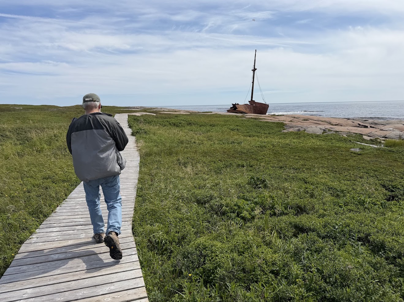
Kegaska is the town at the end of the road. And if you are traveling route 138, you really have to go here. Take a picture of the Route 138 “Fin” sign and explore this beautiful little town. Kegaska also has a ferry terminal, in case you are wanting to continue your journey by sea. And it has a lovely public seaside park. In addition, there is the Brion, a beautiful ship stranded on the rocks here since 1976. While here, we explored the park and Brion. Totally worth the time to walk up to this beautiful area.


Want to go further?
Want to go even further up the coast? You’ve got to take the ferry. And not just any ferry. The Bella Des Gagnes is a cargo ship, ferry and cruise ship all rolled up into one! You can’t drive your vehicle onto this ferry. Instead– if it is a standard size– it is driven into a cargo container and lifted onto the ship’s deck. If your vehicle is oversides (like our dear blue bus, Babe) It is lifted, sans container(!)

The Bella Desgagnes, stops at several remote villages on its way up the coast. And you have the opportunity to get out and explore at each port. If you plan ahead, you can book a berth with a bed. If not, you can sleep in one of the many inside observation rooms, with showers available. (That’s what we did.)The ship has a cafeteria and fancy dining room, also a bar where you can attend natural history lectures about the area (in French).


We had a real adventure on this boat and we wouldn’t trade our experience for anything. But expect the unexpected if you plan to sail the stormy, foggy, remote Cote Nord.

So Much More To See!
Though we have twice roadtripped up Quebec’s Cote Nord, there is still so much we haven’t seen in this beautiful, wild part of Canada. This guide can be a starting point for your own explorations. The Whale Road is perfect for camping and exploring in a van or camper. An awesome road trip in a little known part of the world. Check it out!

Discover more from Following Our Blus
Subscribe to get the latest posts sent to your email.